
Growth and preservation: Land use policy change and the creation of Brunswick Landing
April 10, 2026
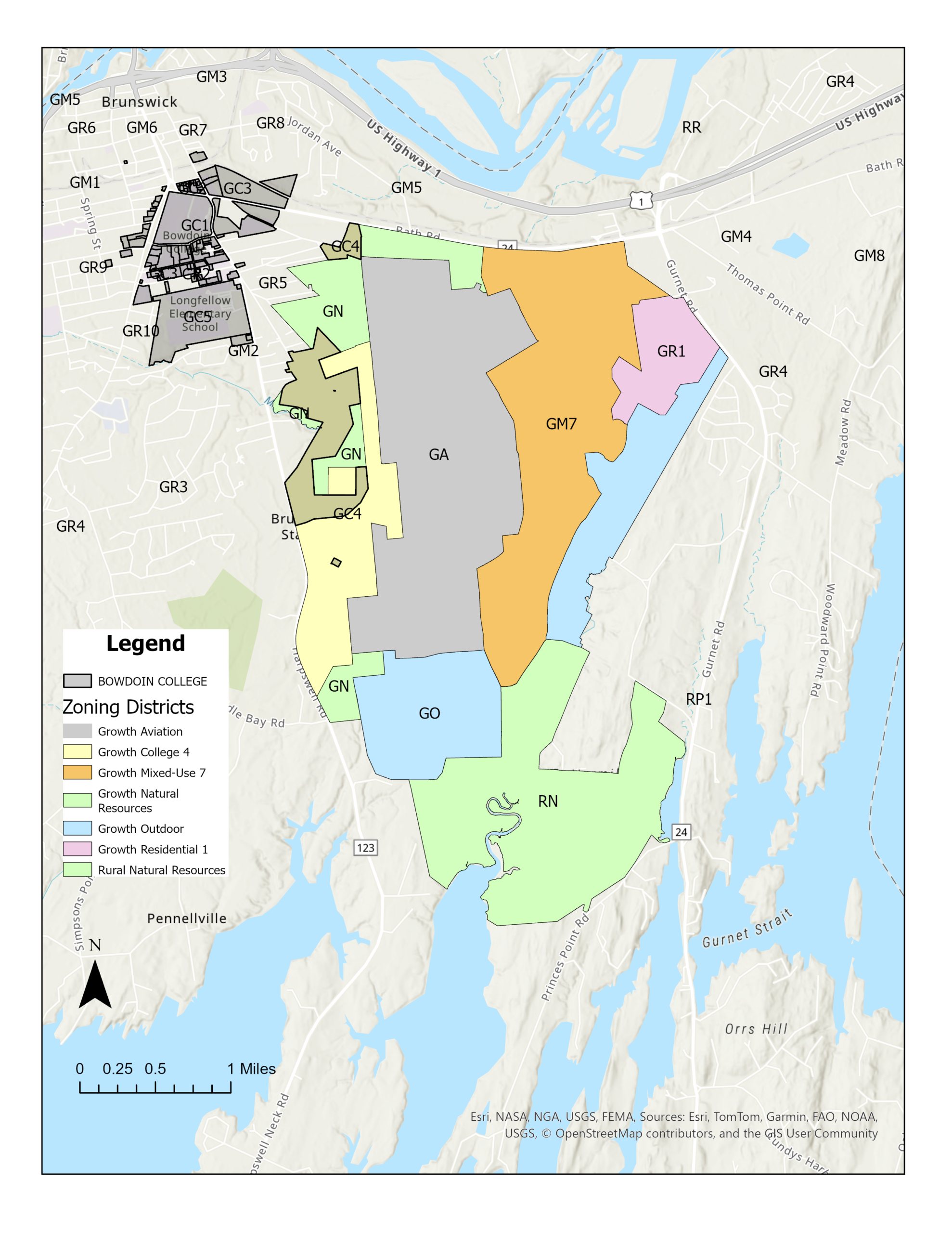 Julia Dickinson (DATA: Town of Brunswick GIS DATA)
When the U.S. Navy left the Brunswick Naval Air Base (NASB), 3,200 acres were left vacant. What would happen to a now-defunct military facility?
After exploring the NASB’s history and peeking into the aftermath of its closure in previous reporting, the Orient investigated the origins of Brunswick Landing.
MRRA management
The Maine State Legislature created the Midcoast Regional Redevelopment Authority (MRRA) in 2009. The MRRA was “entrusted with acquiring and managing the properties within the geographic boundaries of Brunswick Naval Air Station.”
Ultimately, the MRRA was commissioned with carrying out the NASB Reuse Master Plan, which specified land use, transportation and open space elements of the former NASB to fortify the area “as a unique asset within the greater Brunswick community and Midcoast Maine region.”
The Maine Legislature tasked the MRRA with a series of goals: In the short term, the MRRA was asked to “recover civilian job losses in the primary impact community resulting from the base closure.” The estimated 700 jobs lost when the NASB closed were replaced by 2015.
The intermediate and long-term goals focused on recovering the $140 million in economic losses from the closure of the NASB and creating over 12,000 jobs through the redevelopment of base properties. The goal was to make Brunswick Landing more of an economic boon to Midcoast Maine than the NASB had been.
The MRRA has reallocated about half of the NASB’s land for development, while the other half has been dedicated to recreation, open space and nature. With this transfer of ownership and governance to the MRRA, the area was renamed “Brunswick Landing” to reflect its transition to civilian purposes.
Zoning
The Town of Brunswick, like nearly all municipalities in the United States, uses zoning laws to regulate land development. Importantly, zoning is designed to keep incompatible land uses—such as the runways of a naval base and housing—separated. However, zoning is also used to manage economic growth and encourage community development.
For the MRRA to execute its goals, Brunswick needed to update its zoning to allow for new land uses within the NASB property. The new zoning also needed to reflect the MRRA’s balance between development and the preservation of natural resources.
As a result, seven different zoning districts, as determined by the Town of Brunswick, fall within the bounds of Brunswick Landing.
The zone at the bottom of the region is dedicated solely to “preserve, maintain and enhance” the preexisting natural areas that were left untouched by the NASB. This area includes spaces such as the Kate Furbish Preserve, which is operated by the town and features walking trails. The preserve is Brunswick’s largest open space property and is intended for passive use, aligning with the area’s zoning for natural resource preservation.
While the largest natural zone is in the south, smaller zones to the east and north—many of which include walking trails, such as the Brunswick Landing Perimeter Trail—are also zoned to protect natural resources in more developed areas of Brunswick Landing.
As of 2020, the College owns about 130 acres—roughly four percent—of the NASB’s former land. This area is split between natural resource zones and a designated zone for the College’s growth.
Bordering the southern natural resource area are two outdoor growth zones intended for open and recreational space, not just preservation. Mere Creek Golf Club, for example, operates in this section of Brunswick Landing. The active-use zoning of this open space provides more development opportunities than would be possible in the conservation zones.
The Brunswick Executive Airport (BXM) occupies the aviation zone, which includes the former runways and aircraft facilities used by the NASB. Like Brunswick Landing, the BXM is operated by the MRRA.
The eastern portion of the NASB houses the mixed-use and residential zones, which are also zoned as growth areas. This zoning seeks to improve the livability of Brunswick Landing by permitting new housing and business construction.
In particular, the inclusion of mixed-use zoning is notable. Zoning areas such as Maine Street for mixed-use development is fairly intuitive, given its long history as a business district in Brunswick. However, the MRRA started from scratch with Brunswick Landing, given the lack of preexisting business presence in the area.
The town emphasizes that the mixed-use zoning in Brunswick Landing is “intended to provide a compact pedestrian-oriented mix of uses at Brunswick Landing that will provide a variety of live, work, play and education opportunities.”
Developers have taken advantage of these opportunities. Businesses ranging from Wild Oats Bakery and Cafe to med-tech company Mölnlycke have moved to Brunswick Landing in the years since the NASB closed, and housing built there has alleviated some concerns regarding Brunswick’s housing shortage.
Economic development
In addition to changes in local zoning that have redefined land use in Brunswick Landing, the MRRA’s work to encourage economic growth in the area was supplemented by the designation of an Internal Revenue Service (IRS) Opportunity Zone encompassing Brunswick Landing and other parts of eastern Brunswick, including Cook’s Corner.
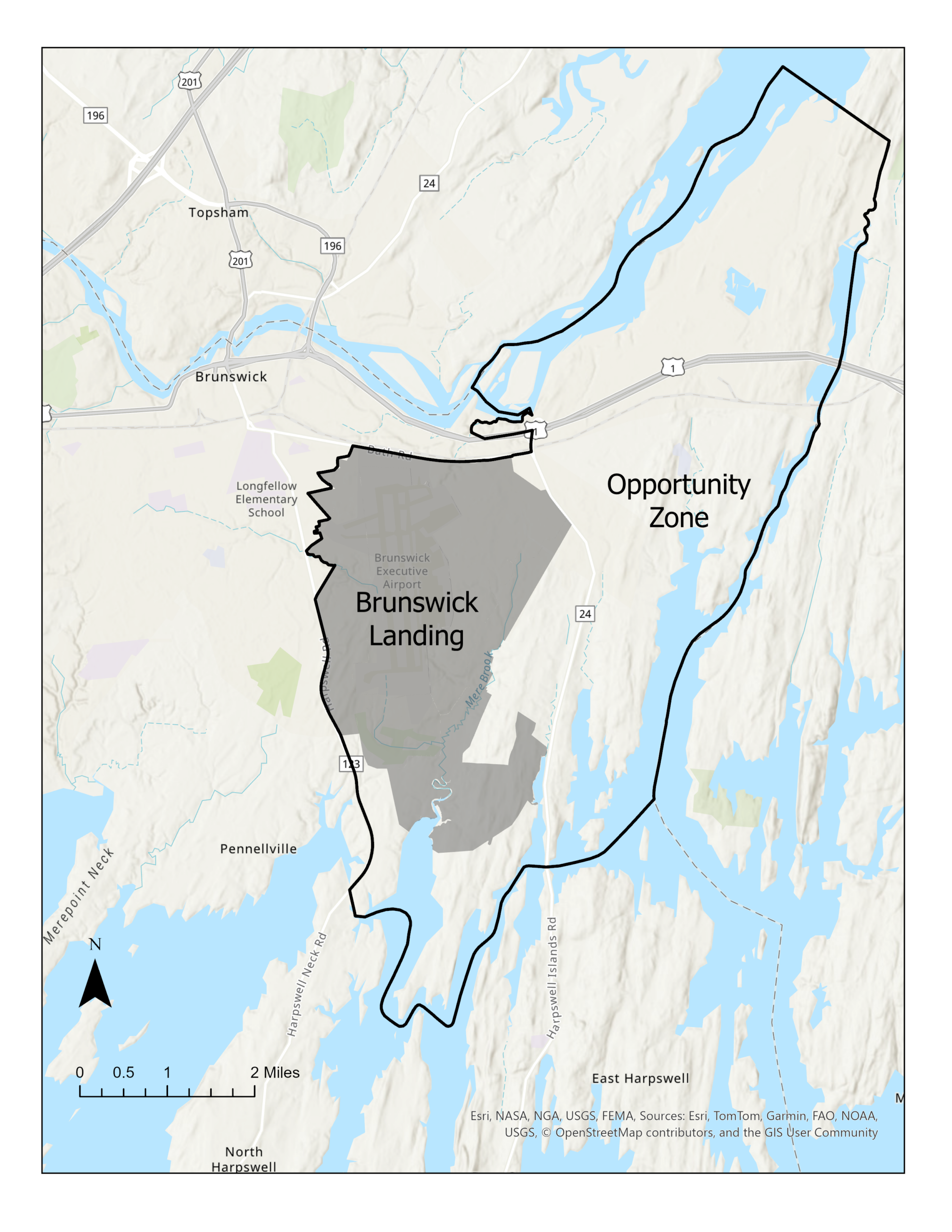 Julia Dickinson (Data: Town of Brunswick GIS Data)
State governors and the IRS work together to create these zones, which are designed to encourage private and public investment in “economically distressed” communities. These investments are made possible by providing tax benefits for qualifying property investments in these zones.
Brunswick’s Opportunity Zone is among the few in Greater Portland and Midcoast Maine, making its designation significant for the government’s goals for the region. The zone was established in 2018 and is set to expire at the end of this year.
This regulatory designation brought its intended economic growth: Today, the MRRA markets Brunswick Landing as “Maine’s Center for Innovation.” According to the MRRA, its work has created 2,800 jobs, and 126 businesses are now based in Brunswick Landing.
What’s next?
“Brunswick is at a critical point in its land use management—the pressures to balance growth demands and land preservation have never been greater,” the 2025 Brunswick Comprehensive Plan reads.
Brunswick’s last comprehensive plan was released in 2008, before the NASB closed.
Looking ahead, the town seeks to implement form-based zoning to prioritize mixed-use development and the relationship between buildings, streets and public spaces. The implementation of form-based zoning in Brunswick Landing would contrast with Brunswick’s traditional zoning, in which incompatible land uses are separated.
According to the comprehensive plan, using form-based zoning should “encourage vibrant neighborhoods with a mix of affordable and market rate housing, mixed-use development and green space” in Brunswick Landing.
As Brunswick Landing’s presence in the town’s economy continues to grow, its land use policy will continue to shift.
This is the second in a series of articles published this spring documenting Brunswick’s transition from a navy town to a college town. Read now: From sonar to solar: A history of the Brunswick Naval Air Station and Bowdoin College
Comments
Before submitting a comment, please review our comment policy. Some key points from the policy: