
Slip ‘n slide: The Shore That’s Sure to Make Your Day
February 18, 2022
 Jane Olsen
If you embark on just a 10-minute drive from campus, you may stumble upon the ecological and historical gem that is Skolfield Shores Preserve. After around five minutes of walking on the preserve, you will be met with a view of the ocean.
The preserve is to the right off of Harpswell Road and after taking a quick left into the parking lot by the Harpswell Heritage Land Trust sign, you have arrived. Harpswell Heritage Land Trust, to whom ecological and cultural preservation is central, purchased the preserve as a part of a Special Places for Harpswell Campaign in 2002.
On your journey, you will pass the Merrucoonegan farmland which, depending on the season, will be characterized by luscious fields or an equally striking blanket of snow. Make your way past the sign and down a short path that briefly crosses over the road. From there, it is up to you whether to follow the Hemlock or the Merrucoonegan trail, both of which take you around Middle Bay Cove. I made this trip on a Wednesday between classes and because I stopped many times to admire the pines above me or to take a photo of my footprints in the snow, I decided to venture to the historic boathouse and spend more time admiring the view rather than completing the entire trail loop. For me, this was the perfect length. Factoring in a good amount of time for getting lost in my surroundings, the whole endeavor took an hour from start to finish.
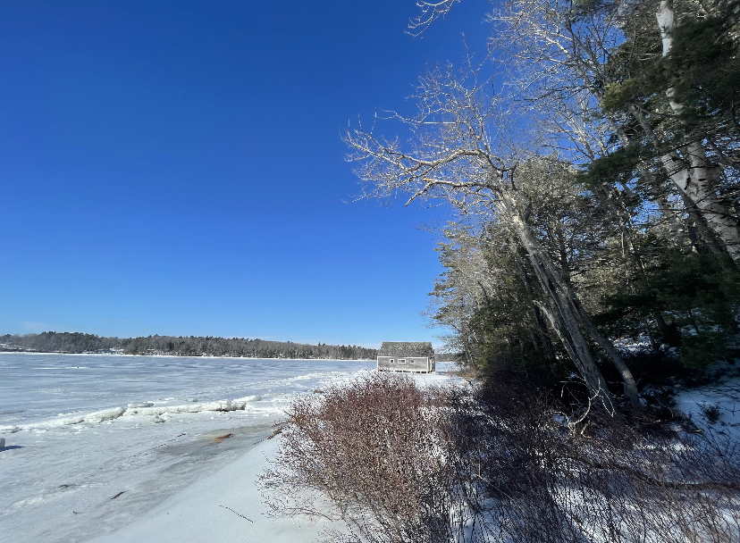
The path to the water is not long. You’ll know that you’re close when the trees marked with yellow open up into a meadow. At the base of this meadow, a set of wooden make-shift stairs lead down to the water. On the day that I happened upon this secret walkway, the ice was the most daunting part of the trip. If I’m being honest, I did end up sliding down to the shore with my friend Lily right behind me. When we gathered ourselves and recovered from our laughing fit we were met with a beautiful view of the cove and a boathouse nearby on the shore. Maybe this is not the best place to take your older relatives in the wintertime, but it’s perfect for capturing a photo to send to them.
The original boathouse was built around 1911 to store a prized boat, the Iris. However, during a big storm in the 1970s, both the house and the boat floated up the bay. The boat house seen today was rebuilt using the same original design, which reminds visitors of the history of the land.
The name of the boathouse, “Merrucoonegan,” is derivative of a Native-American term for “easy carrying place,” alluding to the frequency of canoes arriving to the shore. As time progressed, timber was harvested by the British and sawmills were commonly seen on the shores. In 1757, Thomas Skolfield, the son of a wealthy Irish landholder, came to America with the Orr family, the later owners of Orr’s Island.
It was not until a few generations later that they built the farmhouse at Merrucoonegan Farm. The family became well known for their shipbuilding business and ships as long as 232 feet could be built and sent off during the highest tides of the year.
As I stood gazing out at the ice-covered cove around me, it was difficult to imagine that ships left the bay with cotton, fish, wood and apples on their way to Europe and returned with wine, iron and immigrants. As I made my way through the pines, understanding the context of the rich history made me grateful to have found such a valuable environment right down the road from campus. Before we even apply, Bowdoin encourages students to connect with the community that surrounds us. While I have certainly heard of Gelato Fiasco and watched the sunset at Simpson’s point, there are so many places around campus that many students are unaware of, including myself.
The mission of the College itself emphasizes “a particular responsibility to use nature as a resource for teaching and engaging students,” in order to maintain a relationship with the community and solve environmental challenges of Brunswick. I hope to truly explore the community around me, not only to marvel at the sights but also be grounded in an understanding as to how these places and people came to be, and what they mean for Maine and Brunswick today.
Comments
Before submitting a comment, please review our comment policy. Some key points from the policy: